ShopMay 15, 2026
-

Id’d Civil War Officer’s Camp Trunk – Lt. David E. Parsons Co. A 19th Maine Infantry
$1,650Id’d Civil War Officer’s Camp Trunk – Lt. David E. Parsons Co. A 19th Maine InfantryMay 15, 2026 -
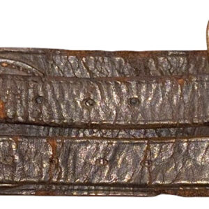
Early Civil War Confederate Belt
$750Early Civil War Confederate BeltMay 13, 2026 -
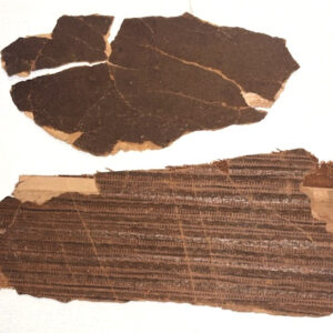
Wallpaper from Clara Barton’s Missing Soldiers Office
$450Wallpaper from Clara Barton’s Missing Soldiers OfficeMay 12, 2026 -
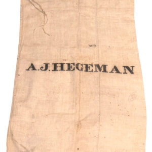
Civil War Duffle Bag – Id’d to Private Abram J. Hegeman Co. I 2nd New York Veteran Cavalry
$350Civil War Duffle Bag – Id’d to Private Abram J. Hegeman Co. I 2nd New York Veteran CavalryMay 11, 2026 -
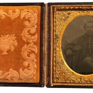
Id’d 1/6 Plate Tintype of Private Oliver P. Townsend Co. B 35th Massachusetts Infantry
$475Id’d 1/6 Plate Tintype of Private Oliver P. Townsend Co. B 35th Massachusetts InfantryMay 10, 2026 -
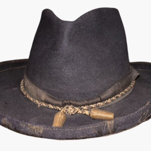
Civil War Officer’s Slouch Hat
$4,250Civil War Officer’s Slouch HatMay 9, 2026 -
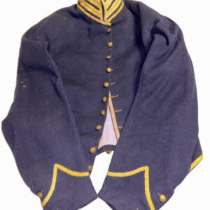
Civil War Cavalry Shell Jacket Likely Constructed at the Schuylkill Arsenal
$2,750Civil War Cavalry Shell Jacket Likely Constructed at the Schuylkill ArsenalMay 6, 2026 -
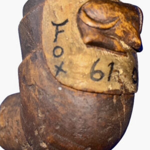
Civil War Period Carved Pipe Depicting “Fox” the Canine Mascot of the 61st Ohio Infantry
$950Civil War Period Carved Pipe Depicting “Fox” the Canine Mascot of the 61st Ohio InfantryMay 6, 2026 -
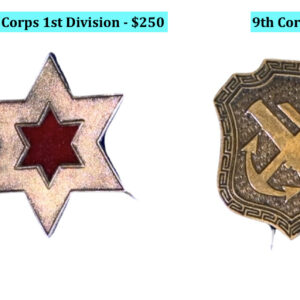
Original Civil War Corps Badges
Original Civil War Corps BadgesMay 6, 2026 -
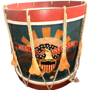
Regulation Civil War Issue Eagle Drum
$4,500Regulation Civil War Issue Eagle DrumMay 6, 2026 -
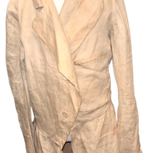
Antebellum Linen Plantation Jacket or Duster
$1,150Antebellum Linen Plantation Jacket or DusterApril 28, 2026 -
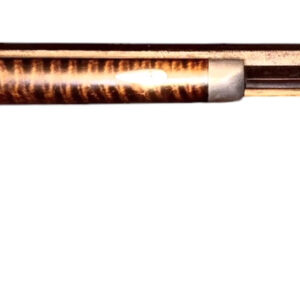
Mid-19th Century Half-Stock Percussion Rifle Made by Mansfield, Ohio Gunsmith John Rickets
Mid-19th Century Half-Stock Percussion Rifle Made by Mansfield, Ohio Gunsmith John RicketsApril 27, 2026 -
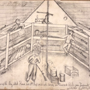
Rare Soldier Drawn Detailed Sketch of the Camp Quarters of Co. K of the 21st Massachusetts Infantry
$1,250Rare Soldier Drawn Detailed Sketch of the Camp Quarters of Co. K of the 21st Massachusetts InfantryApril 22, 2026 -
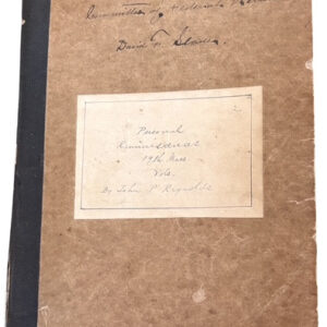
Handwritten Personal Account of the 19th Massachusetts Infantry’s Actions During the Peninsula Campaign Written in 1897 by Capt. John P. Reynolds Co. D 19th Massachusetts Infantry
$1,250Handwritten Personal Account of the 19th Massachusetts Infantry’s Actions During the Peninsula Campaign Written in 1897 by Capt. John P. Reynolds Co. D 19th Massachusetts InfantryApril 16, 2026 -

Rare Early Edition of “Sketch of the Battles of Gettysburg, July 1st, 2d, and 3d, 1863… Accompanied by an Explanatory Map” by T. Ditterline – Published in New York by C.A. Alvord, 1864; copyright dated 1863
Rare Early Edition of “Sketch of the Battles of Gettysburg, July 1st, 2d, and 3d, 1863… Accompanied by an Explanatory Map” by T. Ditterline – Published in New York by C.A. Alvord, 1864; copyright dated 1863April 14, 2026 -
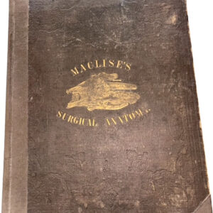
Rare Civil War Period 1st Edition Surgical Anatomy Folio Treatise – “Surgical Anatomy” by Joseph Maclise Published in 1855
$550Rare Civil War Period 1st Edition Surgical Anatomy Folio Treatise – “Surgical Anatomy” by Joseph Maclise Published in 1855April 13, 2026 -
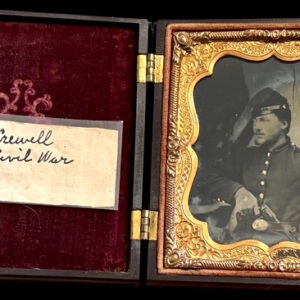
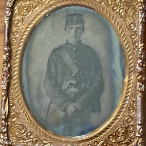
Id’d Ambrotype of Private Philip Crewel Co. F 34th New York Infantry
Id’d Ambrotype of Private Philip Crewel Co. F 34th New York InfantryApril 13, 2026 -
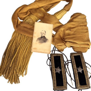
Id’d Grouping – General’s Sash, Brigadier General’s Rank Straps, High Grade Officer’s Belt and CDV of General Ralph P. Buckland 72nd Ohio Infantry
$2,850Id’d Grouping – General’s Sash, Brigadier General’s Rank Straps, High Grade Officer’s Belt and CDV of General Ralph P. Buckland 72nd Ohio InfantryApril 12, 2026 -
Id’d 1/6 Cased Ambrotype of Private Ezra D. Fenton Co. A 34th NY Infantry
$475Id’d 1/6 Cased Ambrotype of Private Ezra D. Fenton Co. A 34th NY InfantryApril 11, 2026 -
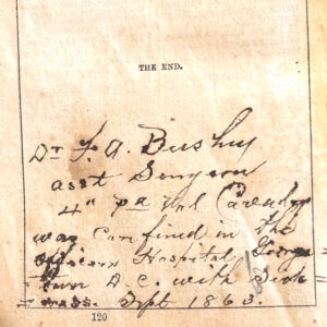
Civil War Id’d Bible Carried by Surgeon Franklin A. Bushey Field & Staff 3rd Pa. Infantry, Field & Staff 4th Pa. Cavalry
$575Civil War Id’d Bible Carried by Surgeon Franklin A. Bushey Field & Staff 3rd Pa. Infantry, Field & Staff 4th Pa. CavalryApril 11, 2026