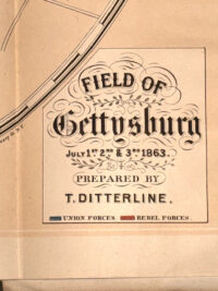
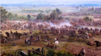
Rare Early Edition of “Sketch of the Battles of Gettysburg, July 1st, 2d, and 3d, 1863… Accompanied by an Explanatory Map” by T. Ditterline – Published in New York by C.A. Alvord, 1864; copyright dated 1863April 14, 2026


 Handwritten Personal...$1,250
Rare Early Edition of “Sketch of the Battles of Gettysburg, July 1st, 2d, and 3d, 1863… Accompanied by an Explanatory Map” by T. Ditterline – Published in New York by C.A. Alvord, 1864; copyright dated 1863
SOLD
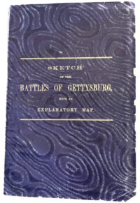
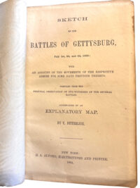
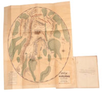
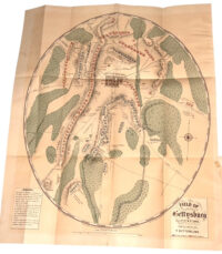
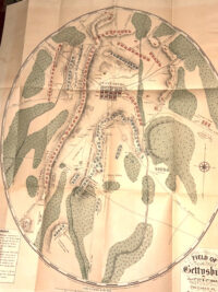
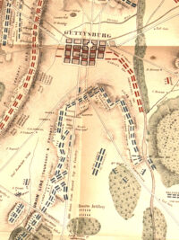
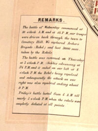
Rare Early Edition of “Sketch of the Battles of Gettysburg, July 1st, 2d, and 3d, 1863… Accompanied by an Explanatory Map” by T. Ditterline – Published in New York by C.A. Alvord, 1864; copyright dated 1863 – This extremely rare 24 page pamphlet contains an original chromolithographic map of the “Field of Gettysburg,” published within mere months of the battle, considered the first map of the battlefield, with the original rarely found 24-page pamphlet with which it was issued, compiled “from the personal observation of eye-witnesses of the several battles” and regarded as the first separately published work to document the battle and likely issued before Lincoln delivered his Gettysburg Address. Within the pamphlet is a day-by-day account of the momentous battle, including the rarely found large chromolithographed folding map of the battlefield after a drawing by northern cartographer Theodore Ditterline. Widely considered the first map of the battlefield, the local Gettysburg newspaper, The Adams Sentinel, in its October 20, 1863 issue, called it “a very distinct and correct map of the battle-field… The details are quite minute and will be highly satisfactory to all who feel an interest in the three day’s fight.” With Union forces color-outlined in blue, and Confederate forces in red, the map also highlights positions of batteries, corps, divisions and brigades, as well as buildings, commanders, headquarters, road, drainage and railroads, and relief by hachures for terrain.
Ditterline’s map was praised by publisher George Childs of the Philadelphia Public Ledger in an October 23, 1863 announcement that expressed his high opinion of the map, “which is shared by several officers in the battle.” At the time “the military’s desire to create an accurate historical record of key battles merged with a broader popular impulse to memorialize heroism and sacrifice. Mapping where corps, brigades, units and individuals fought became a way to immortalize their roles in famous battles” (Knowles, Hillier, Placing History, 246). Ditterline’s map is highlighted in Nelson’s authoritative Mapping the Civil War, which notes it clearly displays “the famous ‘fish-hook’ line held by General Meade’s army on the second and third days of the battle” (96-97). Regarded as the first separately published work to document the battle, likely issued before Lincoln delivered his Gettysburg Address, this pamphlet was compiled “from the personal observation of eye-witnesses of the several battles,” most of whom were war correspondents, and was issued so quickly that it left out “Pettigrew’s and Trimble’s commands entirely in describing how Pickett’s three brigades made the attack” (Reardon, Pickett’s Charge, 65). On the last text page, Ditterline offers thanks to “the several correspondents of the press who were present and witnessed the battles, and from whose descriptions of the fight he has freely extracted; as also to the citizens of the town, and particularly to D. McCenaughy”—referring to Gettysburg attorney David McConaughy, president of the Gettysburg Battlefield Memorial Association. Ditterline’s map, printed by lithographers Duval and Son, Philadelphia, was issued together with this pamphlet: typical of a practice in which “some compilers and publishers added descriptive text to their battle maps… to further expand on the information depicted cartographically”.
Condition – The covers and pamphlet remain in overall very good condition; there are some relatively minor nicks to the front and back covers, with some minor toning to the edges of the pamphlet pages; the map remains in excellent condition retaining strong, vibrant colors.
Map Measurements – Original chromolithograph map, 17” by 19.75” (unfolded).
Related Items
-
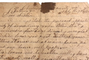
Letter Written by Sergeant Henry L. Camper Co. D 28th Va. Infantry Describing the Mine Explosion or the Battle of the Crater a Day after the Explosion July 31, 1864; Accompanying the Letter are Assorted Family Period Images and Ephemera
$1,950Letter Written by Sergeant Henry L. Camper Co. D 28th Va. Infantry Describing the Mine Explosion or the Battle of the Crater a Day after the Explosion July 31, 1864; Accompanying the Letter are Assorted Family Period Images and EphemeraApril 1, 2026 -
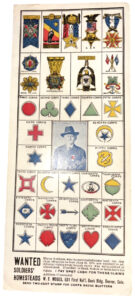
Early 1870s Unusual Ad in the Form of a Decorative Blotter for Purchasing Ex-Civil War Union Soldier’s Homestead Grants – Offered by a Former Officer in the USCT Heavy Artillery
Early 1870s Unusual Ad in the Form of a Decorative Blotter for Purchasing Ex-Civil War Union Soldier’s Homestead Grants – Offered by a Former Officer in the USCT Heavy ArtilleryNovember 10, 2025 -
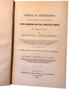
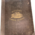
Rare 1st Edition Civil War Medical Book Entitled: A Manual of Etherization : Containing Directions for the Employment of Ether, Chloroform, and Other Anæsthetic Agents, by Inhalation, in Surgical Operations; with Instructions for the Preparation of Ether and Chloroform, and for Testing Them for Impurities. Comprising, also, a Brief History of the Discovery of Anæsthesia – By Charles T. Jackson
$850Rare 1st Edition Civil War Medical Book Entitled: A Manual of Etherization : Containing Directions for the Employment of Ether, Chloroform, and Other Anæsthetic Agents, by Inhalation, in Surgical Operations; with Instructions for the Preparation of Ether and Chloroform, and for Testing Them for Impurities. Comprising, also, a Brief History of the Discovery of Anæsthesia – By Charles T. JacksonJanuary 24, 2026 -
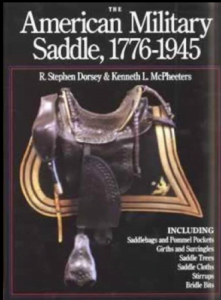
The American Military Saddle by Stephen Dorsey and Kenneth L. McPheeters
$350The American Military Saddle by Stephen Dorsey and Kenneth L. McPheetersJune 8, 2020